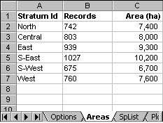
The Areas sheet lists the forest strata that occur in the Tree data table, and gives their areas in ha. In this sheet, the stratum ID must be in column A, and the areas in hectares in column C. Column B is not required, but is used in this case to check the number of records in each stratum in the tree data. This can be done using the macro StratumRecordCount.
The MakeStandTables macro will compile the tree data into per ha (or per km2) summaries without reference to the area table if only sample plot data is present. However, for stock survey data, the areas are required, otherwise correct per unit area statistics cannot be compiled. Also, for the harvesting model, correct areas must be given in this table.
The strata may represent either statistical strata used as a basis for stratifying a forest inventory, such as forest types, soil associations, etc, or real administrative and management units. For stand tables, either type of usage is equally valid and acceptable. However, for the Harvest model, the strata should represent contiguous blocks that will be felled, wholly or partially, in defined sequence over the felling cycle. They should therefore be administrative units such as compartments or periodic blocks.
It should also be noted that a single stratum or block is a perfectly valid basis for either stand tables, or for the harvest model.